
Coming Up: Transportation Master Plan
On Tuesday, the Infrastructure & Protective Services Committee will be discussing a new Transportation Master Plan. It is recommended that Committee send this to Council for approval on August 24th.
This Master Plan is an incredibly important document. Once approved, it will guide our capital spending on roads. It also has impacts on land use planning and other City programs.
This Master Plan has been in the works for several years. Traffic data, public engagement, and the expertise of many City departments have gone into forming it Which all makes for a lengthy document, weighing in at 305 pages.
You can read it for yourself here.
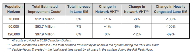
The Plan makes recommendations for what type of upgrades the City should make to our road network before several different population milestones: 70 000 people (about where we are right now), 90 000 people, and 120 000 people.
I’ll be sharing my takes on the Master Plan after I’ve had a chance to ask some questions at Committee.
But as this conversation approaches, I thought I’d share some of the most significant graphics within it. These are presented in the order they appear in the Master Plan.
The cost and benefits of recommendations at each population milestone (pg iv):
Places where road and intersection improvements are recommended for each population milestone (pg v):
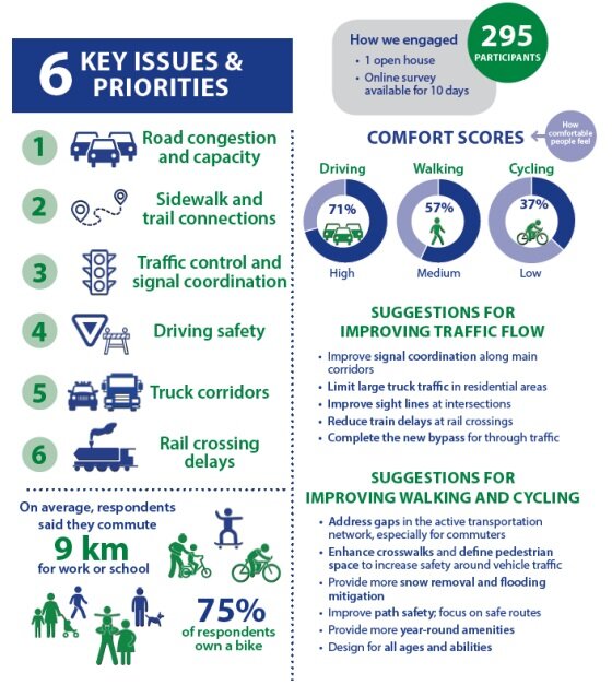
Some highlights of public engagement results (pg 17):
The most problematic sections of road identified through public engagement (pg 23):

Population growth and impact on the road network at 120,000 people (pg 40): (shaded areas represent where new people are expected to live, coloured lines represent where our roads are expected to be congested if no improvements are made between now and then)

How many new lane kilometres are proposed for each population milestone (pg 74):

Where injury accidents are currently happening in the city (pg 96):
